

Jöklaleiðin - The Glacier Trail
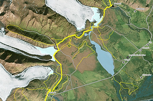
Vatnajökull - Hornafjörður
Jöklaleiðin is a 250 km long hiking route extending from Núpsstaðarskógur to the remote landscapes of Lónsöræfi. As the longest planned hiking trail in Iceland, it weaves together some of the country’s most striking terrains — glacial forelands, black sands, birch valleys and high mountain ridges — and connects 45 of Iceland’s 100 highest peaks.
To date, 42 km of the full 254 km route have been formally planned and designed.
HAX has led the design, development and project management of Jöklaleiðin, working across multiple years and project phases. The work includes route planning, spatial design, site analysis, stakeholder coordination, interpretive concepts and infrastructure development in close collaboration with local landowners, municipalities, Vatnajökull National Park and national agencies.
The project aims to cultivate slow, nature-based travel deeply rooted in ecological sensitivity. Old tracks, historic paths and new connections are integrated to create a coherent and safe route that enhances access while protecting fragile environments. Each segment of the trail is developed with careful attention to landscape character, sustainability and long-term stewardship.
Jöklaleiðin is ultimately a framework for understanding Iceland’s glacial and volcanic landscapes — a continuous thread that invites visitors to move gently through shifting terrains while strengthening the relationship between nature, community and sustainable tourism.

Snapshot from Ölduslóð - Öræfi

Ölduslóð
Skaftafell - Freysnes - Svínafell
An 8 km walking and cycling trail in Öræfi that weaves together services and accommodation through a landscape of exceptional natural character.
Areas once separated by glacial rivers are now connected, enabling safe and sustainable travel across this unique glacial region.

Breiðamerkursandur
Fjallsárlón - Breiðamerkurlón
A nearly 15 km hiking route between Fjallsárlón and Breiðamerkurlón.
A unique walk across ever-shifting glacial sands shaped by the forces of Fjallsárjökull and Breiðamerkurjökull.
Mýraslóð
Skálafell - Haukafell
A 22 km walking trail in Mýrar that follows three outlet glaciers of Vatnajökull — Skálafellsjökull, Heinabergsjökull and Fláajökull.
A route that offers a unique experience of shifting glacial landscapes, where quiet wetlands, moraines and wide horizons reveal the slow movements of ice over time.